4.1
11 review
Everyone
Content rating
1.8K
Downloads


About this product
OpenStreetMap / MapQuest
OutScout - Locations & Tracks description
GPS location-tracking tool for your outdoor-activitiesOpenStreetMap / MapQuest
★ FEATURES OVERVIEW ★
• Maps (default, cycling, public transport)
• Location storage (layer based)
• GPS tracking (with statistics)
• Compass (with Augmented reality mode)
• Distance measurement
• Geocoding (reverse, GPS coordinates)
• Altimeter
★ MAPS
Choose between different types of maps (Default, Cycle, Transport).
Maps datasource is powered by OpenStreetMap-data with tiles courtesy of MapQuest.
★ LOCATION STORAGE
Store your geolocation-favorites, arranged on different layers, which can be hidden/displayed on the fly.
Set up a custom map-indicator (select a color + icon) for your geolocation-layer.
Quick navigation from one location to another is easy via management-area next/below the map.
You can even take geolocation photos to be stored with each of the locations.
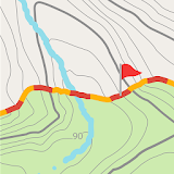
★ GPS TRACKING
With the tracking feature you're able to record your trips.
Detailed statistics about distance, duration, speed,.. are easily shown.
Recorded tracks can be hidden/displayed on the fly.
You can even stop recording, and resume later, even at another point...
★ COMPASS
A small compass-overlay can be displayed on the map.
Your devices gyroscope (if available) is used to stabilize azimuth-measurement.
The built-in augmented reality feature allows to target remote locations and show distances/direction to stored location.
★ DISTANCE MEASUREMENT
Measure linear distances from your position to another, or even between to remote points.
★ REVERSE GEOCODING
Your exact location is shown on the map.
GPS coordinates and actual address information is shown next to the map.
★ ALTIMETER
Your current altitude is shown (optional, if gps enabled) in the statusbar next to/below the map.
Altitude is determined from gps-data.
★ PORTRAIT / LANDSCAPE
This app can be used on your demands in portrait and landscape mode.
★ DATASTORAGE
All recorded positions and tracks are stored locally (on your device).
Pictures don't mess up your devices picture-galery as they are only accessible from inside the app.
★ HOW TO manage layers, geolocations, track log records
Below the map (on the left side in landscape) you can see a moveable statusbar.
Move it up (to the right in landscape) until the management-area comes into view.
The management-area contains 3 pages (slidable horizontally).
On the first page ('LAYERS') you can add layers as a container for locations / geopoints
* Click 'Add new layers' at lists bottom to add new ones
* Press-and-hold existing list-items to edit/delete
* Click item to toggle visibility of layer's locations / geopoints
* Click '+' button to add new locations / geopoints (placed at current map's center)
On the second page ('LOCATIONS') you can see all currently visible locations
* Click to quick-center on map
* Press-and-hold to edit/delete
On the third page ('TRACKS') you can manage your track log records
* Click 'Add new track' at lists bottom to add new track logs
* Click on newly created track items to toggle recording-state (paused <-> recording)
* Click on 'Finish' button to finalize track-log recording
* Click on finalized item to toggle visibility on map
* Click 'Center-Arrow' button to quick-center track / route
★ PRO UPGRADE
The free version has a limited number of layers, locations and tracks you can add.
You can upgrade to an ad-free and unlimited version any time.
Location storage, GPS tracking, Compass, Distance measurement, Altimeter - all rolled into one!