3.2
103 review
Everyone
Content rating
0
Downloads


GNSS Radar description
GNSS Radar is an application to show the current GNSS (Global Navigation Satellite System) constellation at a specified location. The application supports all GNSS system such as GPS, GLONASS, Galileo, BeiDou, QZSS, and SBAS.TLE (Two line elements) is used for simulate the satellite position. When you start up the application, the current TLE is downloaded via internet.
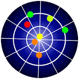
[SKY PLOT]
GNSS satellite constellation in the sky.
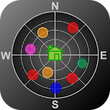
[SAT MAP]
Satellite position on the map.
You can set the observer location (house icon) by drag and drop.
[DOP / NSAT]
Charts of number of satellites and DOP (Dilution Of Precision) over 5 hours.