0.0
0 review
Everyone
Content rating
535
Downloads


About this product
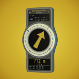
Direction Distance Meter description
- Displays the direction on the compass the current terminal is facing.- Displays the direction and distance on the compass of the specified coordinates.
- The coordinates of the time signal radio station are preinstalled, it can be used immediately to check the direction of the time adjustment of the radio clock.
- In addition to preinstalled coordinates, it can also use coordinates on the map.
- Since it can specify the coordinates directly, it can be used for navigation to a place without a road.
- It can store the movement route by continually acquiring the current location from the GPS sensor and recording it. (The tracking function)
- It can create route chart by tapping of start/via/target point on the map. (The route chart function)
- It can display saved tracking data and route chart data on the map.
- It can be backed up as one file at once of the coordinate data, tracking data, and route chart data. (Backup function at terminal exchange)
- It can be sent and received via e-mail of the coordinate data, tracking data, route chart data, and backup data.
- It can be exported the coordinate data, tracking data, route chart data to KML file. (The exported KML file can be used with Google Maps etc.)
- Since it can easily send and receive the current coordinates, how about installing in preparation for rescue of a huge disaster such as an earthquake and storm.
- The tracking function can check the total moving distance and average speed, so it can be useful for walking, jogging, cycling, touring, driving, etc.
- The Route chart function is displayed the total moving distance from the departure point to the target point, so it can compare which route is closest to the destination.
- Not if you want to know the direction of your home, famous mountains(Everest,etc.), religious facilities(Qibla,etc.) from the current point? Even in such a case this application will be useful.
[Disclaimer]
- Developer is not responsible for any damage or losses of any kind caused by the install or use or misuse of this application.
- This app uses acceleration sensor, magnetic sensor, GPS sensor of terminal. Therefore, it can't be used on terminals that non installed those sensor.
- The direction and coordinates of this app use the value of the terminal sensor, This app can't ensure the accuracy of the terminal sensor value.
- The route chart function is not a navigation system. It is a function of designate a route on the map on yourself and create a route chart.
- In this app, when you execute the tracking function, the location data is acquired in the background.
- "Google Maps" is a trademark or registered trademark of Google Inc.