3.7
37 review
Everyone
Content rating
8.6K
Downloads


About this product
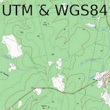
Bearing (Azimuth) Navigation description
This app provides two modes: Azimuth and GPS tracker.Azimuth mode.
Allows you to navigate according to a given bearing (azimuth).You create the bearing line on the map and start walking. You also see your walking path. The bearing lines are created according to North Magnetic Pole. The features are:
- draw waypoints on the map
- the map storages in the cache memory, so offline mode for the app is possible
- draw bearing line from the current location or waypoint location
- display your distances from the beginning and from the end of bearing line
- display your deflection from the bearing
- share bearing lines and waypoints via messaging capability applications
GPS tracker mode.
Allows you to work together with MTK electronic system for aircraft models and navigate directly to the model. The features are:
- display all distances, altitude, flight time and other information
- possibility to select aircraft model for navigation
- multiuser mode
- possibility to use smart watch together or instead (standalone) smartphone
- possibility to use all functions of the azimuth mode as well
- the manual: https://drive.google.com/open?id=1lei7q90cyQ5pxQtcO7DKaQoSchPn_jBN
All your proposals and comments are welcome!